


du col de la chaudiere aux 3 becs

verozerr
User
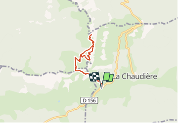

Length
6.9 km

Max alt
1565 m

Uphill gradient
640 m
Km-Effort
15.5 km

Min alt
1026 m

Downhill gradient
641 m
Boucle
Yes
Creation date :
2021-07-20 09:46:22.237
Updated on :
2021-07-20 15:15:16.133
4h41
Difficulty : Medium

FREE GPS app for hiking
 SityTrail
IGN / Geographical institutes
SityTrail Plus
The world is yours!
About
Trail Nordic walking of 6.9 km to be discovered at Auvergne-Rhône-Alpes, Drôme, La Chaudière. This trail is proposed by verozerr.
Description
col de la chaudiere , pas de Siarra et 2 premiers pics des 3 becs
Positioning
Country:
France
Region :
Auvergne-Rhône-Alpes
Department/Province :
Drôme
Municipality :
La Chaudière
Location:
Unknown
Start:(Dec)
Start:(UTM)
674866 ; 4944120 (31T) N.
Comments